Saturday, May 29, 2010

Golden Temple : Amritsar


Sri Harmandir Sahib, also known as Sri Darbar Sahib or Golden Temple, (on account of its scenic beauty and golden coating for English speaking world), is named after Hari(God) the temple of God. The Sikhs all over the world, daily wish to pay visit to Sri Amritsar and to pay obeisance at Sri Harmandir Sahib in their Ardas.

Guru Arjan Sahib, the Fifth Nanak, conceived the idea of creating a central place of worship for the Sikhs and he himself designed the architecture of Sri Harmandir Sahib.  

Despite its great sacred status, the Golden Temple is open to visitors, like all Sikh temples. 

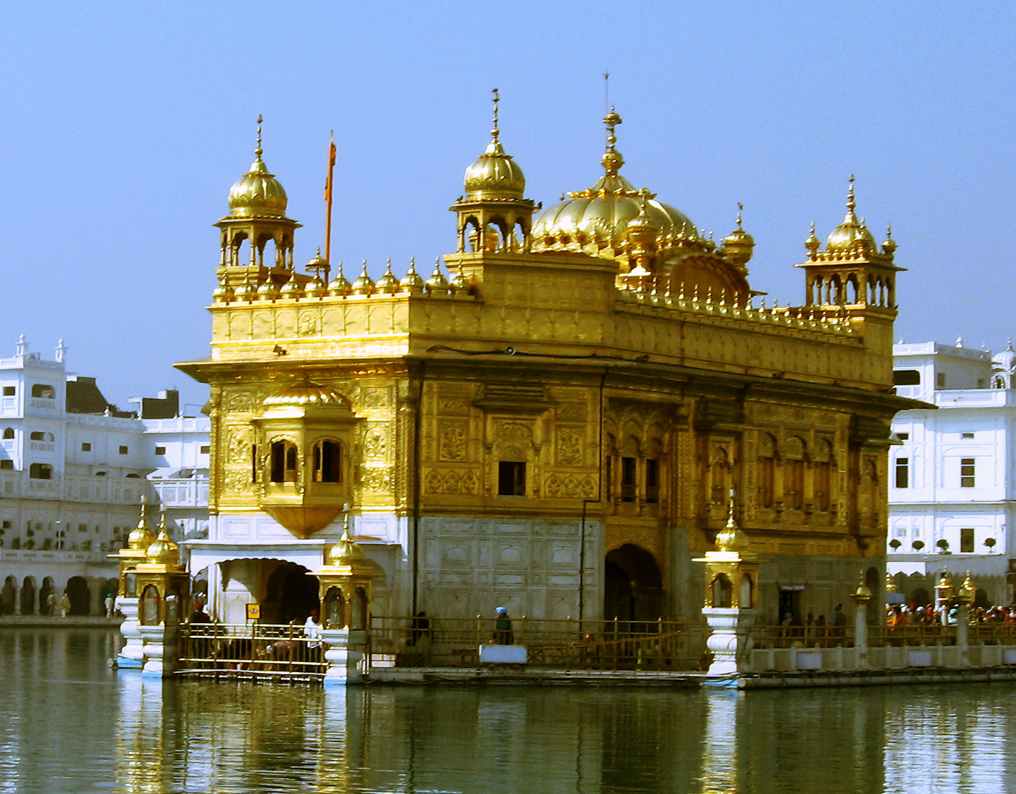
The most famous and sacred part of the Golden Temple complex is the Hari Mandir (Divine Temple) or Darbar Sahib (Court of the Lord), which is the beautiful golden structure at the center of a large body of water. The gold-plated building features copper cupolas and white marble walls encrusted with precious stones arranged in decorative Islamic-style floral patterns. The structure is decorated inside and out with verses from the Granth Sahib (the Sikh holy book). 

The water that surrounds the Hari Mandir is a sacred pool known as the Amrit Sarovar (Pool of Nectar). The temple is reached by following the Parikrama, which circumscribes the sacred pool in a clockwise direction. Connecting the pathway with the Hari Mandir is a marble causeway called the Guru's Bridge, which symbolizes the journey of the soul after death. The gateway to the bridge, the Darshani Deorhi, has magnificent silver doors. 

Another major highlight of the Golden Temple complex is the Guru-ka-Langar, a dining hall where around 35,000 people a day are fed for free by temple volunteers. Everyone is invited to join this communal breaking of bread. All participants sit on the floor, regardless of caste, status, wealth or creed, powerfully symbolizing the central Sikh doctrine of the equality of all people. 

Sri Harmandir Sahib, is built on a 67ft. square platform in the centre of the Sarovar(tank). The temple itself is 40.5ft. square. It has a door each on the East, West, North and South. The Darshani Deori (an arch) stands at the shore end of the causeway. The door frame of the arch is about 10ft in height and 8ft 6inches in breath. The door panes are decorated with artistic style. It opens on to the causeway or bridge that leads to the main building of Sri Harmandir Sahib. It is 202 feet in length and 21 feet in width.
 
Location-Amritsar,Punjab

 
Co ordinates- 31.620045° N, 74.876397° E 

How to reach the destination:

Air : 

Flights operate to the Rajasansi airport at Amritsar from many national destinations. A few international flights also land at the airport.

Rail : 

Amritsar is well connected by railway network. Regular trains operate between Amritsar and national capital Delhi.

Road : 

Buses are available to Amritsar from Delhi and other destinations of Punjab. Amritsar is at a distance of 234 kms from Chandigarh and 464 kms from Delhi.


Amarkantak : Madhya Pradesh


Amarkantak  is a pilgrim town and a nagar panchayat in Anuppur District in the state of Madhya Pradesh, India. Also called "Teerthraj" (the king of pilgrimages), Amarkantak region is a unique natural heritage area and is the meeting point of the Vindhyas and the Satpuras, with the Maikal Hills being the fulcrum. This is where the Narmada River, the Sone River and Johila River emerge.

Amarkantak is a Sanskrit word the literal meaning of which is immortal (amar) obstruction (kantak). The place was abode of Gods but was disturbed by the hindrances of Rudraganas and hence called Amarkantak. The poet Kalidas has mentioned it as Amrakoot. Myth is that the dense forests of this region were full of mango (amra) trees. So Kalidas named it as Amrakoot, which later became Amarkantak.
  
Religious importance of Amarkantak:
Amarkantak situated on the western edge of ancient Kingdom of Kalinga is a place of worship for all the three worlds. Gods and Gandharvas (Celestial beings), Asuras (demons), Saints and Sages  have all achieved great spiritual powers here. It is believed that who ever dies at Amarkantak is assured of a place in heaven. Also if a lady makes offerings of fruits and flowers will gain the respect of her husband, and no doubt she will also achieve a place in heaven.

When Lord Shiva destroyed Tripura (The three cities) by fire, the ashes of one fell upon mount Kailash, the ashes of another fell upon Amarkantak, and the ashes of the third were saved by Lord Shiva and kept in heaven. The ashes that fell upon Amarkantak turned into crores of Shivalingas. Only one is visible at Jwaleshwar in Amarkantak.

Places of tourist importance:

Amarkantak being a unique natural heritage is very rich in biodiversity. It has got a number of places of scenic beauty. Apart from this it is source of origin of three important rivers. It is a great pilgrim center for Hindus. It is thus a great-unexplored tourism destination.
  
Narmadakund and temples
At the place of origin of Narmada River there is an open pool known as Narmadakund. Around this kund there are number of temples such as Narmada and Shiva temple, Kartikey temple, Shri Ram Janki temple, Annapurna temple, Guru Gorakhnath temple, Sri Shuryanarayan temple, Vangeshwar Mahadev temple, Durga temple, Shiv Pariwar, Siddheswar Mahadev temple, Sri Radha Krishna temple, Eleven Rudra temple etc.

Ancient temples of Kalachuri period 

The ancient temples of Kalachuri period are situated in the south of Narmadakund just behind it. These were built by Kalachuri Maharaja Karnadeva (1042-1072 AD). The Machhendranath and Pataleshwar temples are excellent examples of architecture. There is also Keshav Narayan temple built by the Bhonsle ruler of Nagpur in the 18th century.

Sonemuda

Sonemuda is the place of origin of Sone River. It is situated at a distance of 1.5 km from Narmadakund at the very edge of Maikal Mountain. The Sone River cascades from the mountain in a waterfall hundreds of feet long.


Mai ki Bagiya (Goddess garden)
A grove of trees in dense forests situated at a distance of one km from Narmadakund is named “Mai ki Bagiya” in honour of the goddess Narmada. In this natural garden there are Mango, Banana and other fruit trees along with Gulbakavli, roses and other flower plants.


Kapildhara (Kapil waterfall)
Six km northwest of Narmadakund is the Kapildhara waterfall with a fall of about hundred feet. According to scriptures, Kapil Muni lived here. There is a scene of natural beauty with mountains and dense forest down hills.


Kabir chabutra (the platform of saint Kabir)
It is an old belief that the great saint Kabir performed austerities here and achieved spiritual powers. It is therefore a holy place for the Kabir panth sect.


Shri Jwaleshwar Mahadev (the temple of Shiva)
The Jwaleshwar temple and the source of origin of the third river Juhila River is situated at a distance of 8 km from Amarkantak on Shahdol road. According to ‘Vindhya Vaibhav’ Lord Shiva himself established a Shivling here and also scattered crores of other Shivlings over Maikal Mountain

 Location-Annupur,Madhya Pradesh
Coordinates 22°40′N 81°45′E / 22.67°N 81.75°E

How to reach destination:

By Air
The nearest airport to Amarkantak is at Jabalpur, which is 245 km away from City of Amarkantak. Pre-paid taxi services are available from airport to Amarkantak costing about Rs 3,000 for the journey.

By Bus
There are state owned transport buses from Pendra Road, Shahdol and Bilaspur. Amarkantak is connected by buses to Jabalpur (245 km), Rewa (261 km) and Shahdol (67 km).

By Train
The nearest railhead to Amarkantak is Pendra Road at a distance of 17 km from the heart of the city. Anuppur at distance of 48 km from Amarkantak is also convenient for the tourists. Taxi charges are Rs 300 from Pendra Road and Rs 600 from Anuppur.

Mount Abu : Rajasthan


Mount Abu  is the highest peak in the Aravalli Range of Rajasthan state in western India. It is located in Sirohi district. Mount Abu is 58 km from Palanpur (Gujarat). The mountain forms a distinct rocky plateau 22 km long by 9 km wide. The highest peak on the mountain is Guru Shikhar, at 1722 meters above sea level. It is referred to as 'an oasis in the desert', as its heights are home to rivers, lakes, waterfalls and evergreen forests. Ancient Name of Mount Abu is "Arbudaanchal".
 

A pleasant retreat set amidst the lush forested hills, Mt. Abu is a green oasis in the barren desertscape that's Rajasthan. Situated at the southern tip of the Aravali range the hill retreat owes its cool climate to its rich flora covering the entire hillside that includes coniferous trees and flowering shrubs.

The only hill station in Rajasthan, Mount Abu is more than just a summer retreat. Its stunning array of exquisite Dilwara Jain Temples, dating back 11th- 13th centuries, make it a popular pilgrimage centre. Abu according to a legend stands for the son of Himalayan, deriving its name from Arbuada, the powerful serpent who rescued Nandi, the sacred bull of Lord Shiva, from a chasm.

Mount Abu has been home to many sages and saints.


Location-Rajasthan
Coordinates -24°35′33″N 72°42′30″E / 24.5925°N 72.7083°E
What to see:
Gaumukh Temple: A natural spring flowing through a sculpted cows head gives the shrine its name. The famous yagna of sage Vashishtha was performed here. A beautifully sculpted hill temple of Arbuada-the mighty serpent stands against the beautiful backdrop. Nearby is the magnificent marble image of Nandi, the celestial bull rescued by Arbuada.

Dilwara Jain Temple: These beautifully carved temples built between 11th and 13th century A.D. are sheer elegance in marble, dedicated to the jain Tirthankaras. The Vimal Vasahi temple is the oldest of these dedicated to the first Tirthankara. Built in 1031 A.D. (by Vimal Shah-a merchant and representative of then Gujarat ruler), it is a superb example of temple architecture.

Adhar Devi Temple: The temple is chiselled out of a huge rock reached by a flight of 360 stairs. A favourite tourist spot. 

Sunset Point: Spectacular sight of the setting sun when the hills are covered in the golden glow can be viewed from here. 

Honeymoon Point: Also known as Andra Point, it offers an enchanting view of the verdant plains and valleys. The place looks most beautiful during the dusk hours. 

Gardens and Parks: Beautifully laid parks and gardens are interspersed throughout the hilly paradise. Ashok Vatika,Gandhi park, Municipal Park,Shaitan Singh Park and Terrace Garden are some of the noteworthy gardens. 

Museum and Art Gallery: Located at the Raj Bhawan, it was a collection of archaeological excavations dating back to 8th-12th century A.D. It also has Jain bronze carvings,brassworks etc. for viewing.

How to reach the destination:
  • Air : Nearest  airports are Udaipur and Ahmedabad.  
  • Rail: Nearest  railhead is Abu Road (27 kms). 
  • Road: By road  Mount Abu to Ahmedabad 214 kms, Bombay 835 kms, Delhi 768 kms, Jaipur 515 kms, Udaipur 182  kms, Jodhpur 291 kms, Ranakpur 168 kms. 
  • Bus : Regular  buses connect Mount Abu with Abu Road, Achalgarh, Ahmedabad, Ranakpur, Ahmedabad, Udaipur,  Abu Road. 
  • Taxi: Taxis and  Jeeps are available from Abu Road to Mount Abu. 

Athirapally Waterfalls : Kerala


Athirappally Falls is one of the best places to visit in Kerala and is a major tourist attraction place. The soothing sounds take you to the nature’s most relaxing, rejuvenating place, East of Chalakudy, “The Athirappally Waterfalls” in Kerala, Athirappally is an 80ft high waterfall which literally takes your breath away. Starting calmly from the high ranges, and crashing through gorges overhung with trees, this waterfall is one of the best places in India to re-capture a real sense of the classical idea of the “Picturesque”. It is not just calm and sweet, but something wild and natural.

The Athirappilly Falls are situated on the Chalakudy river, which originates in the upper reaches of the Western Ghats. Many endangered and endemic species of flora and founa are found in the forests of the Athirapilly-Vazhachal area. This area is the only place in the Western Ghats where four endangered Hornbill species are seen.  

Athirapally waterfalls are quite popular with film directors because of its eye-catching scenery. 

Location-Thrissur,Kerala
Best time to visit- June -October during monsoon.

How to reach the destination:

By Air :

Athirapally Waterfall is just 90 kilometers away from Cochin. The nearest airport is Cochin and tourists can get to Athirapally by road from here.

By Road:

Bus services are available from Chalakudy on the Cochin-Trichur highway. 

By Rail: 

The Chalakudy Railway Station is around 30 kilometers from Athirapally and tourists can hire a cab or taxi from the station to Athirapally.

Friday, May 28, 2010

India Gate : New Delhi


The India Gate is the national monument of India. It is one of the largest war memorials in India. Situated in the heart of New Delhi, India Gate was designed by Sir Edwin Lutyens. Originally known as All India War Memorial, it is a prominent landmark in Delhi and commemorates the 90,000 soldiers of the while British Indian Army who lost their lives fighting for the British Indian Empire.

Following India's independence, India Gate became the site of the Indian Army's Tomb of the Unknown Soldier, known as the Amar Jawan Jyoti (Immortal Soldier)..It is made up of red sand stone and granite.

The 42-metre tall India Gate is situated such that many important roads spread out from it.

Amar Jawan Jyoti
Burning in a shrine under the arch of India Gate since 1971 is the Amar Jawan Jyoti (the flame of the immortal warrior) which marks the Tomb of the Unknown Soldier. The shrine itself is a black marble cenotaph with a rifle placed on its barrel, crested by a soldier's helmet. Each face of the cenotaph has inscribed in gold the words "Amar Jawan" (Immortal Warrior).
This cenotaph is itself placed on an edifice which has on its four corners four torches that are perpetually kept alive. It was unveiled in 1931.
Today, it is customary for the President and the Prime Minister, as well as visiting Guests of State, to pay homage at the site on occasions of State ceremonies, and each Republic Day, 26 January, the Prime Minister pays homage to the soldiers along with Heads of Armed Forces, before joining the annual parade at the Rajpath.
Location-New Delhi
co ordinates-28°36′46.31″N 77°13′45.5″E / 28.6128639°N 77.229306°E / 28.6128639; 77.229306  
How to reach the destination:
  • One can board DTC and private buses from any location within Delhi. Buses to India Gate can be taken from the Inter State Bus Service or the ISBT.
  • By auto or cabs from anywhere in Delhi
  • There are frequent buses from Sarai Kale Khan Bus Terminal
  • One can find buses for India Gate at Connaught Place,delhi.
  • Metro Rail Service can be used to reach India Gate. The nearest metro station to India Gate is Central Secretariat.

Amarnath Cave Temple : Jammu & Kashmir


The Amarnath caves are one of the most famous shrines in Hinduism, dedicated to the god Shiva, located in the Indian state of Jammu and Kashmir. The shrine is claimed to be over 5,000 years old and forms an important part of ancient Hindu mythology. 

Inside the main Amarnath cave lies an ice stalagmite resembling the Shiva Linga, which waxes during May to August and gradually wanes thereafter. This lingam is said to grow and shrink with the phases of the moon, reaching its height during the summer festival. According to Hindu mythology, this is the cave where Shiva explained the secret of life and eternity to his divine consort Parvati.There are two other ice formations representing Parvati and Shiva's son, Ganesha.

It is a popular pilgrimage destination for Hindus - about 400,000 people visit during the 45-day season around the festival of Shravani Mela in July-August, coinciding with the Hindu holy month of Shraavana.

No pilgrim is allowed to proceed for the yatra without proper registration. A medical certification is a must before registering as a pilgrim.

The ICY IDOL:

The cave shrine of Amarnath can be accessed only during these rainy months of July and August, when inside the cave, a pure white ice-mound is formed, and water trickles down in a slow mysterious rhythm from the top of the cave on top of it. It piles up to take the shape of a 'lingam', the phallus symbol representing Lord Shiva, which begins to rise undiscernibly to acquire a full shape on the full moon night. It is believed that water from the Ramkund Lake situated above the cave, falls drop by drop on the holy Shiva Lingam.

Location--Amarnath,Jammu & Kashmir

Coordinates: 34°12′54″N 75°30′03″E / 34.2149°N 75.5008°E

How to reach the destination:

By Air: 
The nearest aerodrome is Srinagar. There are daily flights to Srinagar from Delhi and Jammu. On some week days flights also pickup passengers from Chandigarh and Amritsar .

By Rail: 
Jammu is the nearest Railway Station . It is well connected with all stations of India.

By Road: 
Jammu and Srinagar are also connected through road. Buses and Taxies are also available for this part of the journey .These can be hired on daily as well as full tour basis.


Vaishno Devi Temple : Jammu & Kashmir


Vaishno Devi Mandir is one of the holiest Hindu temples dedicated to Shakti located in Jammu& Kashmir.In Hinduism, Vaishno Devi, also known as Mata Rani and Vaishnavi, is a manifestation of the Mother Goddess.

.This holy shrine of Mata Vaishno Devi which is situated in the folds of mighty 'Tirkuta' Hills' attracts lakhs of devotees from all parts of India and abroad .

The Vaishno Devi temple is recognized as one of the "Shakti Peeths" of goddess ' Durga'.
The temple is near the town of Katra, in the Jammu district in the state of Jammu and Kashmir. It is one of the most revered places of worship in Northern India. The shrine is at an altitude of 5200 feet and a distance of approximately 13.5 kilometres (8.38851 miles) from Katra. Approximately 8 million pilgrims (yatris) visit the temple every year and it is the second most visited religious shrine in India .

The scenic beauty, the landscape around and the constant chanting of 'Jai Mata Di', leaves a mystic effect on the devotees. At the culmination of their pilgrimage the devotees are blessed with the 'Darshans' of the deity in her three manifestations as three Pindies, located inside the sanctum- sanatorium, which is open for the devotees through out the year in all seasons. .

Significance-
The Trikuta Mountain where the Shrine is located and the Holy Cave are the gateway to the dimension of the Super Consciousness. And just like the Trikuta Mountain, which is one at the base but has three peaks, the revelation of the Mother Goddess in the Holy Cave is in a natural rock form which is one at the base but has three heads at the top. These three heads in a natural rock form are known as the Holy Pindies and are thus worshipped as the revelation of the Mother Goddess.

The main Darshans remain to be of the three heads called the Holy Pindies. The uniqueness of the Holy Pindies is that although they emanate from one single rock form, each one is distinctly different from the other two in colour and texture.

MAHA KALI Towards the right is the Holy Pindi of Mata Maha Kali (the Supreme Energy of Dissolution) in the colour associated with Her i.e. black. 

MAHA LAKSHMI In the centre is the Holy Pindi of Mata Maha Lakshmi (the Supreme Energy of Maintenance) with a yellowish-red tinge, the colour associated with Mata Maha Lakshmi.
 
MAHA SARASWATI The Pindi to the extreme left of the viewer is worshipped as the Holy Pindi of Mata Maha Saraswati (the Supreme Energy of Creation). It has a whitish tinge when looked at attentively.
 
Location-Katra, 61-km From Jammu, J&K
Yatra Season:March-April And September-October
Best Time To Visit::March To July 


How to reach the destination:
The nearest Railway Station and Airport are at Jammu, at a distance of 50 Kms from Base camp Katra. A regular bus services are plying from Railway Station, Air port and General Bus Stand Jammu to Katra.

The Mata Vaishno Devi Shrine is linked to the Base Camp Katra with a 13 Kms track. The entire uphill Journey from Katra to Bhawan is on foot, however, one can hire ponies, palkies or pithoo for ease of journey.

Lotus Temple : Delhi


The Bahá'í House of Worship in Delhi, India, popularly known as the Lotus Temple due to its flower like shape  is a Bahá'í House of Worship and also a prominent attraction in Delhi. It was completed in 1986 and serves as the Mother Temple of the Indian subcontinent.

As with all other Bahá'í Houses of Worship, the Lotus Temple is open to all regardless of religion, or any other distinction, as emphasized in Bahá'í texts. `Abdu'l-Bahá, the son of the founder of the religion, stipulated that an essential architectural character of a House of Worship be that it requires to have a nine-sided circular shape.Inspired by the lotus flower, its design is composed of 27 free-standing marble clad "petals" arranged in clusters of three to form nine sides.
The site is in the village of Bahapur, in the National Capital Territory of Delhi. The architect was an Iranian, who now lives in Canada, named Fariborz Sahba. 
Since its inauguration to public worship in December 1986, the Bahá'í House of Worship in Delhi has, as of late 2002, attracted more than 50 million visitors, making it one of the most visited buildings in the world. Books written on lotus temple are:
  • Forever in Bloom: The Lotus of Bahapur, Photographs by Raghu Rai, text by Roger White, Time Books International, 1992
  • The Dawning Place of the Remembrance of God, Thomas Press, 2002
It has won numerous architectural awards and been featured in hundreds of newspaper and magazine articles.
 
Location- New Delhi
  
Time to Visit: On all days except Monday
 
Preferred Timings: Summer/ Winter: 9:00 a.m. to 7:00 p.m./ 9:30 a.m. to 5:30 p.m. 
 
Coordinates: 28°33′11″N 77°15′31″E / 28.553088°N 77.258735°E

How to reach the destination:
 
Nearest Railway Station : Nizamuddin Railway Station.
 
Nearest Metro Station : Central Secretariat. 
 
Nearest International Airport : Indira Gandhi International Airport .
 
Tourists can either take local buses from various points within the city to reach this temple located in South Delhi, or they can take auto-rickshaws and taxis or metro rail. 
 
Special Attraction:
 
There are four Prayer Sessions everyday. These Prayer Sessions are unique, as prayers from all religions are recited during these Prayer Sessions. Prayer Session Timings: 1000 hrs - 1015 hrs (15 minutes), 1200 hrs - 1215 hrs (15 minutes), 1500 hrs - 1515 hrs (15 minutes), 1700 hrs - 1715 hrs (15 minutes).

Wednesday, May 26, 2010

Qutab Minar : Delhi

The Qutab Minar is a tower in Delhi,India  at 72.5 meters (237.8 ft) the world's tallest brick minaret and was constructed under the orders of India's first Muslim ruler Qutb-ud-din-Aibak.

It is surrounded by several other ancient and medieval structures and ruins, collectively known as Qutb complex. The complex is listed as a UNESCO World Heritage Site. It is one of the most popular tourist destinations in Delhi, and was also India's most visited monument in 2006, as it attracted 3.9 million visitors, even more than the Taj Mahal which drew about 2.5 million visitors..

Its construction commenced in 1193 and the topmost  storey of the minaret was completed in 1386 by Firoz Shah Tughluq.The Quitab Minar is tall with 379 steps leading to the top.The minaret is made of fluted red sandstone covered with intricate carvings and verses from the Quran.Inspired by the Minaret of Jam in Afghanistan and wishing to surpass it, Qutubuddin Aibak the first Muslim ruler of Delhi, commenced construction of the Qutb Minar in 1193, but could only complete its base. His successor, Iltumish, added three more stories and, in 1386, Ala-ud-din constructed the fifth and the last storey..

The Qutb Minar is notable for being one of the earliest and most prominent examples of Indo-Islamic architecture.

Tourist Attractions in Qutab Minar Complex  

Quwwat – Ul – Islam Mosque : Situated north-west of Qutab Minar, Quwwat – Ul – Islam mosque is one of the oldest mosques built in India.The original mosque was built upon a Hindu temple, an inscription over the eastern gateway states that the mosque was built with materials obtained from demolishing ’27 idolatrous temples.’ 

Iron Pillar : Just adjacent to the Quwwat – Ul – Islam mosque is 7.2 mts high Iron Pillar.Another interesting thing about this Pillar is that the iron has not rusted even after more than 1,500 years. Hearsay, if you can catch round the Iron Pillar by your own arms on back projection, your wish will be fulfilled, so you should take a chance. 

 Alai Minar : Head north of the Qutab Minar and the Quwwat – Ul – Islam mosque to see the Alai Minar, the unfulfilled dream of Alauddin Khilji.Khilji planned that he would build a second tower of victory just like the Qutab Minar and it would be twice the height of the former. Alauddin Khilji died during the construction of Alai Minar and the tower could reach only 27 mts high.

Alai Darwaza : Alauddin’s Alai Darwaza, the main entrance to the whole complex is a popular attraction which will fascinate you with its awesome architecture. Built in 1310 A.D, this red sandstone gateway is fully enriched with zafri network and stands just south-east of the Qutab Minar.


Location - Delhi

Co ordinates : 28°31′28″N 77°11′07″E / 28.524355°N 77.185248°E

How to reach the destination.

 1)By Air :

Delhi has two airports – Indra Gandhi International Airport and Palam Domestic Airport. Both these airports are connected with regular flights from important cities of the country and the world as well. Frequent shuttles run between these airports.

2)By Train : 

Delhi has three major railheads namely – Delhi, New Delhi and Hazrat Nizamuddin railway station. These stations are served by many express and super fast trains from various parts of the country.

3)By Bus : 


Good motorable roads including National Highways and State Highway link Delhi with nearby states and rest of the country. 

4)Local Transport : 


Buses, Taxis, Cars, Auto-rickshaws are available as local modes of transport, you can reach Qutab Minar by opting any mode. Metro railway is new attraction in Delhi but presently it is not linked to Qutab Minar.


Monday, May 24, 2010

Taj Mahal : Agra


About Taj Mahal:
  
The Taj Mahal  is a mausoleum located in Agra, India, built by Mughal emperor Shah Jahan in memory of his favorite wife, Mumtaz Mahal.
  
The Taj Mahal  is considered the finest example of Mughal architecture, a style that combines elements from Persian, Indian, and Islamic architectural styles. In 1983, the Taj Mahal became a UNESCO World Heritage Site and was cited as "the jewel of Muslim art in India and one of the universally admired masterpieces of the world's heritage."
  
While the white domed marble mausoleum is its most familiar component, the Taj Mahal is actually an integrated complex of structures. Building began around 1632 and was completed around 1653, and employed thousands of artisans and craftsmen. The construction of the Taj Mahal was entrusted to a board of architects under imperial supervision including Abd ul-Karim Ma'mur Khan, Makramat Khan, and Ustad Ahmad Lahauri. Lahauri is generally considered to be the principal designer.

It is one of the seven wonders of the world. 

Location : Agra

Co ordinates :27° 10′ 27″ N, 78° 2′ 32″ E

State : Uthar Pradesh

How to reach:

1. By Air

Nearest Airport : Agra Airport

Agra Airport is 7 km from the city center and 3 km from Idgah bus stand. Major Indian airlines operate daily tourist shuttle flights to Agra, Khajuraho, Varanasi and back. It only takes 40 minutes from Delhi to Agra.

2. By Rail

Nearest Railway Station : Agra Cantonment station

Agra is well connected by rail to Delhi, Varanasi and cities of Rajasthan. Trains like Palace on Wheel, Shatabdi, Rajdhani, and Taj Express are the best choices if you want to reach Agra from Delhi in luxury. Normal trains are also available in plenty.

3. By Road

Nearest Bus stand :Idgah bus stand 

Idgah bus stand is the main bus stand of Agra, one can catch buses from Delhi, Jaipur, Mathura, Fatehpur-Sikri, etc.

4. Local Transport

You can travel to different parts of Agra using different modes of transport like taxi, tempo, auto-rickshaw and cycle rickshaw from the Taj Mahal area. Prepaid taxis and autos from the railway station are available. Prepaid transport is also available for excursions in and around the city limits. Bicycles can be hired on hourly basis from different parts of the city. It is to be remembered that no diesel or petrol vehicle are allowed to ply in the Taj Mahal area. Battery-operated buses, horse-driven tongas, rickshaws and other pollution-free vehicles are allowed to conserve the beauty of this great monument.